Showing posts with label gorges. Show all posts

Zugreni Gorges

The Zugreni Gorges are formed by Bistriţa River between the Giumalău Massif and the Pietrosul Bistriţei Massif. Zugreni Gorges are located in the central part of the Eastern Carpathians, Suceava County, on Crucea commune territory, at ca. 20 km north-east of Vatra Dornei town. This natural reserve is distributed in the forestry wards of Vatra Dornei and Crucea (Latitude 47'24', Longitude 25'3 1'). With a surface of 100 hectares, the area was declared a geological and floral reserve in 1973.


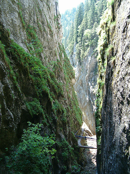
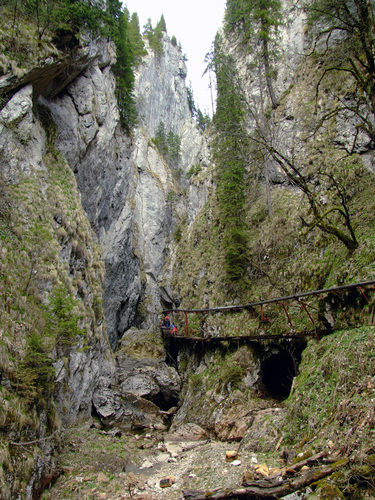
The Bistriţa River is crossing down this reserve on a length of ca. 2 km, making there those gorges relief type. The nature reserve is located on the northern slope of Pietrosul Bistriţei summit (made of gneiss) and on the southern slope of Rarău-Giumalău massif (made of limestone and crystalline schist, belonging to the Jurassic age). According to Koppen, that region has a boreal climate (type Df), with cold, wet winters, and unstable and chilly summers. The average temperature is +4.2 OC per year. The most frequent winds are those from the west (31.7%), while those from the east have a frequency of 9.4%. Those western winds raise the degree of soil humidity by their raining contributions. One can remark the fact that along the Bistriţa river, the winds have a smaller intensity, being channelized by the passage of that valley.


Wilderness of rocks, flora, scenic beauty, make this area a sight of great interest. The first mentions over the flora of that region have been made by D. Brândza (1889); later on, D. Grecescu (1898), A. Procopianu-Procopovici (1906) made other mentions. The Queen flower is found here in the lowest area in the country and is a natural monument, is found here in the lowest state in the country. Also here was detected the presence of endemism Pietrosia levitomentosa (syn. Andvyala levitomentosa), housed in an inaccessible area (on Pietrosul Bogolin summit, at ca. 1750 m.s.l.).

  • Can be seen here Carpathian endemites (in general): Aconitum moldavicum ssp. hosteanum, Campanula rotundifolia ssp. polymorpha, Cardamine glanduligera, Festuca carpatica, Symphytum cordatum, Leucanthemum waldsteinii, Melampyrum saxosum, Poa rehmannii, Campanula carpatica, Phyteuma vagneri;
  • Romanian Carpathian endemites: Aconitum moldavicum ssp. moldavicum, Scabiosa lucida ssp. barbata, Silene nutans ssp. dubia, Dianthus tenuifolius, Eritrichium nanum ssp. jankae, Thymus bihoriensis;
  • Eastern & Southern Carpathian endemites: Gentiana cruciata ssp. phlogifolia, Primula elatior ssp. leucophylla, Ranunculus carpaticus, Hepatica transsilvanica.
  • Some plant species into the natural reserve of "Zugreni Gorges" are pretty rare, such as: Matteuccia struthiopteris, Pinus mugo, Arnica montana, Avenula compressa, Corrallorhiza trijida, Doronicum columnae, Elsholtzia ciliata, Epipogium aphyllum, Ligusticum mutellina, Lilium martagon, Rhodiola rosea, Telekia speciosa, Euonymus nana, Leontopodium alpinum (this last one is situated at only 740 m.s.1. there).

Zugreni is one of the most beautiful and exciting areas of Romania, very popular for spending active holidays or free time (fishing, trekking, hiking, rafting).

Orzea Gorges

Located north of Scropoasa Lake in Bucegi Mountains, Cheile Orzei (Orzea Gorges) are among the tightest, beautiful and spectacular gorges in the Ialomița Valley and even in Romania. The gorges are over 1.5 km long, dug into the limestone walls. In 1970, to protect this valuable space, was created the Orzea Gorges Nature Reserve Complex.


Mixed nature reserves Orzea-Zănoaga and Zănoaga-Lucăcilă includes Zănoaga karst systeme: Big Zănoaga Gorges, Little Zănoaga Gorges, Orzea Gorges - all nature monuments, forests of spruce (Pices abies), a thermophilic vegetation consisting of rare Southern-European, Southern-Mediterranean and Balkanic floristic elements: mountain rye (Secale montanum), iris (Iris dacica), Sorbus cretica, Carduus candicanus, Athamantha hungarica, Phleum montanum, Lonicera caerulea, Astragalus depressus, and many others.


Orzea Gorges are guarded by stone walls of 100-300 m high, between Lespezi Mountain and Orza–Brânduşi Mountain. Here, Ialomița Valley is very narrow and provides an exciting spectacle of the falls on the stones. At the end of the gorges are the Scropoasa lake and dam.


Images from here, here, and here.

Runcu Gorges

The Runcu Gorges (Romanian: Cheile Runcului) are a natural reserve (20 ha) located in the extreme north of Alba County, at the Cluj County border, situated on the Ocoliş commune territory between Lunca Largă village at north and Runcu village at south. It is a complex reserve, consisting of a very beautiful landscape, a set of slopes, ridges and towers. Access roads: on 75 National Road Turda-Câmpeni up to the confluence of the Ocoliş Stream with the Arieş River, then by the village road towards north, on the Ocoliş Valley, about 5 km until the entry into the Runcului Gorges.


Runcu Gorges are located in the east of the Muntele Mare Massif, on the Ocoliş Stream banks, left tributary of the Arieş River. Geographic coordinates: 46°31'N, 23°22'E. Altitude: 595 m (at the entrance of Ocoliş Stream in the gorges) and 500 m (at the the output of the stream). Runcu Gorge is the most spectacular morphological breakthrough in the Vulturese limestone, not so much by their length, which exceeds 1 km, but by the vertical scale of development, the relief on the perimeter keys sometimes exceeding 450 m. The gorges territory is mostly state owned, in general as unproductive land and forest land, but also in private agricultural use (meadows, pastures, meadows and, in lesser extent, cultivated land). The Runcului Gorges can be crossed by car.


Images from here, © Pompei Cocean

Şugău Gorges

The Cheile Bicazului-Hăşmaş National Park (Bicaz Gorges - Hăşmaş Mountain) is located in north-eastern Romania, in the Eastern Carpathians. The reservation territory is part of Neamţ and Harghita counties. The parks area of 6575 ha is divided into two zones: the special conservation zone (78%), and the protection zone (22%). On the territory of the National Park there are some natural reserves, such as Şugău Gorges.


True open-air museum, Şugău Gorges Natural Reserve is located at the southern edge of Munticelu Massif and can be individualized with a unique landscape and an exceptional natural heritage. Şugău River has carved 350 m long gorges, very narrow (2-3 m wide), and forms a row of waterfalls.


The reserve has a surface of 90 ha; the coordinates of its center are 46gr 51’ N and 25gr 48’E and its highest point has an altitude of 1381 m (Munticelu-Şugău Rock Crest).


The reserve represents an exceptional natural site due to the uniqueness of available natural heritage. Its geology is extremely interesting in terms of tectonic-structural (fractures, tectonic contacts, blades of over-thrust), paleontological (Mesozoic fossils) and petrographic (accumulations of tuff, travertine, limestone of different ages).


The gorges are spectacular due to the reference landscape elements (limestone and karst terrain, vertical walls, limestone towers, narrow gorges, marmite erosion, caves, avens, springs, sinkholes, karst saddles, clints), flora (endemic species, sub-alpine meadows developed on limestone, calcareous screes and slopes specific vegetation, forests of Pinus sylvestris - glacier relic), fauna (chamois, lynx, wild cats, bats, birds, reptiles, amphibians, insects, mollusks) and characterized by rarity or uniqueness.


The Natural Reserve was declared Site of Community Importance under European legislation and will be integrated into the international network of protected areas Natura 2000. Custodian of the protected area is a Romanian Mountain Club (led by Ticu Lăcătuşu), with administrative headquarters in ECOLOGIC Chalet.

Bats' Cave

Bats' Cave or Saint Grigorie Decapolitul's Cave is located in Costeşti commune, Vâlcea County, Oltenia, Romania. One can reach the cave departing from Bistriţa Monastery, at 630 m absolute altitude and 80 m relative altitude, on the right slope of Bistriţa Gorges.


The cave was formed due to erosion caused by Bistriţa River, has three openings, a length of 400 meters, two levels, and a negative oscillation of level of 15 meters. It has a lack of concretionary formations; presenting more openings, the cave is dynamic, ventilated all year, so the thermal amplitude is high, and the climate is humid. In specialty papers, the cave is first mentioned in 1929 by Emil Racoviţă and bio-speleological research were made in 1951 and 1955.


In Romania there are several other caves that bear the name of Bats' Cave, but this one has a religious and zoological importance. In the wall of the lower level is a small church named Ovidenia, partly built, partly carved in the rock, dating from the 17th century. It represents the secret place where were hidden in harsh times the treasures of Bistriţa Monastery and the relics of St. Grigorie Decapolitul. Under the largest opening there is the Holy Archangels church, built by monks Macarie and Daniel in 1635.


The cave is home for several species of bats. Miniopterus schreibersi lives permanently in this cave; Rhinolophus ferrumequinum, Vespertilio pipistrellus, Plecotus auritus, Barbastella barbastellus houses here during the winter; Myotis myotis and Myotis oxygnathus comes here in spring for reproduction and leaves in autumn. On the floor, under the colonies of bats, is a guano layer of 1.7 m thick, where the fauna is very rich (as the trogobiont species), the cave having a great bio-speleological importance.

Photos from here.

Râmeţ Gorges

The Râmeţ Gorges (Romanian: Cheile Râmeţului) are located in the proximity of Râmeţ commune, Alba County, Transylvania, Romania. Developed at the east of the Trascău Mountains, on the middle flow of the Râmeţ Rivulet, the Râmeţ Gorges are among the most important touristic points from the Apuseni Mountains (Western Carpathians). In its upper part, Râmeţ Rivulet is named by the locals Monastery Valley, and in its lower part, Mogoşului Valley; the rivulet is also named Geoagiului Valley.


At the exit of Trascău Mountains, between Trascău, Urmezu and Vulturilor peaks, it formed a gorges zone of 1 km in length. On the entire length of the gorges, there are traces of an old tunnel-shaped cave. The gradual collapse of the cave ceiling eased the further evolution of the gorges. This can be argued by the fact that the keys have a transverse V-profile, wider at the top. The Râmeţ Gorges are extremely narrow, with steep walls. At the basis of the walls there can be found many caves’ entrances.


Eaves presents a large distribution, both in water and suspended, which reflects the stages of deepening of the river stages in the limestone ridge. The most impressive are found in the area called La Cuptoare, where the gorges are very narrow (3-4 m) and the slopes are eave-shaped. In the central part of the gorges, there is a tunnel with a length of about 15 m and a height of 4-5 m.


After leaving the gorges, 3 km downstream, Râmeţ Rivulet form new gorges, near the Râmeţ Monastery. Though having a length of about 100 m, these gorges are spectacular, having the appearance of a huge gate. Slopes have a V-shaped transverse profile, wide open at the top, presenting numerous towers, poles, and grottoes.


Due to the spectacular landscape and to the special karstic elements that it presents, the Râmeţ Gorges have been declared Geological, Paleontological and Speological Reservation since 1969. The reserve consists of limestone massifs since late Jurassic. In the western part prevails conglomerates, sandstones, marls and marno-calcars, and Cretaceous and Mesozoic basalts in the eastern area.


The vegetation of the area is remarkable, with endemic species as Dianthus spiculifolius, Silene dubia, Aconitum moldavicum, Hepatica transsilvanica, Cardamine glanduligera, Viola jooi, Sorbus dacica, Cephalaria radiata, Campanula rotundifolia ssp. kladniana, Centaurea pinnatifoida, Cirsium furiensis and some rare species as Taxus baccata, Geranium macrorrhizum, Cypripendium calceolus, Aquilegia nigricans ssp. subscaposa, Viola biflora, Daphne cnerorum, Geranium macrorrhizum, Sparganium neglectum, Typha shuttleworthii, Herminium monorchis etc.

Because of the abrupt relief, the gorges can be browsed only along the water during the summer, with a good knowledge of the area and a good training!

Nera's Gorges

Nera River springs from the western part of Southern Carpathians, actually from the Semenic Mountains. At the point where Nera River enters Anina Mountains, the water flow has carved out a breathtaking landscape, whose most attractive point is the Nera Gorges; the straits here are extremely spectacular, wild and rather hard to reach. The keys’ surrounding regions make a national park that was founded in 2004 and stretches along an area of about 37,000 hectares.


The Nera Gorges – Beuşniţa Nature Reserve was for the first time protected in 1943. The need was felt to protect the area in terms of landscape, as well as in terms of its biodiversity. At the surface, diversity lies in the Nera Gorges, the biggest of their kind across the country. According to some specialists there are 20 kilometers long, while others describe them as being 22 kilometers long;aAs for the subterranean landscape - caves and other karstic phenomena. And in terms of biodiversity, there are all sorts of species with Mediterranean influence that can only be found in this region.


In terms of landscape, some of Nera Gorges, most admired spots are such crystal-clear water expands such as the Bey’s Eye or the Devil’s Lake, the Beuşniţa and Văioaga waterfalls, as well as tunneled pathways in Sasca Montană.


About one third of Romania’s earth flora can be found in the Park. The fitogeografic analysis shows the predominance of the European elements in a broad sense, 603 species (58.3%), of which 305 Euro-Asian species, 152 European, 124 Central European, 52 circumpolar. It is also noticed in the flora of the park a large number of southern elements: 209 species (about 19%). Endemic species for the Nera Gorges National Park were identified such as the Banat peony (Paeonia maculata), as well as other species, which are Mediterranean and here in the Nera Gorges found a favorable climate due to the heat that can be found on lime stones. Such species are the filbert tree (Corylus colurna), the wig tree (Cotinus coggyria), and many others.


The fauna in the Nera Park is very rich, among rivers, groves and forests. The terrestrial fauna is represented by a number of 313 taxa, 29 endemisms, 45 rare species, out of which 119 species are protected and strictly protected by the Romanian and international law. The Nera river has fish species that can be described as endemic. For instance, here can be found the Aspro Streber, also known as the loach. This kind of fish is a unique case of how the perch can adapt to living in the fast mountain rivers. This species of fish was considered extinct, or on the verge of extinction across the park, but in 2006 several researchers from the Grigore Antipa Museum managed to capture five samples of the species that are now kept at the Museum. Among reptiles, two venomous species stand out, the viper (Vipera ammodytes), and the adder (Vipera berus). We should also mention the Carpathians’ scorpion (Euscorpius carpaticus), which is a real symbol of the Nera Gorges – Beuşniţa National Park, and is even pictured on this protected area’s emblem. The park also has big mammals, such as the wild boar, the bear, the lynx or the wild cat.


Today, tourism is the region's sole source of income, as long as locals and tourists alike respect the rules and boundaries implied by the protected area. Administrators of the Nera Gorges – Beuşniţa National Park are constantly monitoring tourists who enter the area, and step in to take measures in case any of them break park rules. At the entrance, each tourist pays a fee of little over one euro, and is given a leaflet with park rules and a bag for collecting their trash.