Showing posts with label mountains. Show all posts

Mocăniţa

The word mocăniţă is a term of endearment, derived from the Romanian word mocan, meaning shepherd or one who lives in the mountains, and suffixed as feminine and diminutive in keeping with the tradition of naming conveyances and indicating small size. Mocăniţa is a narrow gauge railway in Romania, most notably in Transylvania and nearby regions. They are situated in mountainous areas and the locomotives operating on them (which themselves can also be referred to as mocăniţăs) are steam-powered. These railways were built for cargo and passenger services - some in the era of the Austrian-Hungarian Empire, before 1920 - but fell into disrepair over the years.


Forestry railways were widespread over Europe, especially within the Carpathian Mountains. The operating principles were very simple: following close to the river, in case of need with narrow curves (therefore the use of the narrow gauge!), and constructed to enable the small locos pulling the the empty logging cars up to the mountains and to coast down the heavy loaded trains to the saw mills.


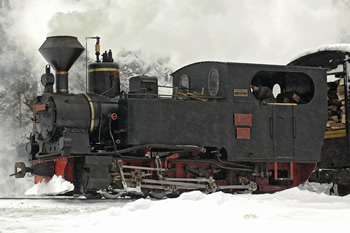
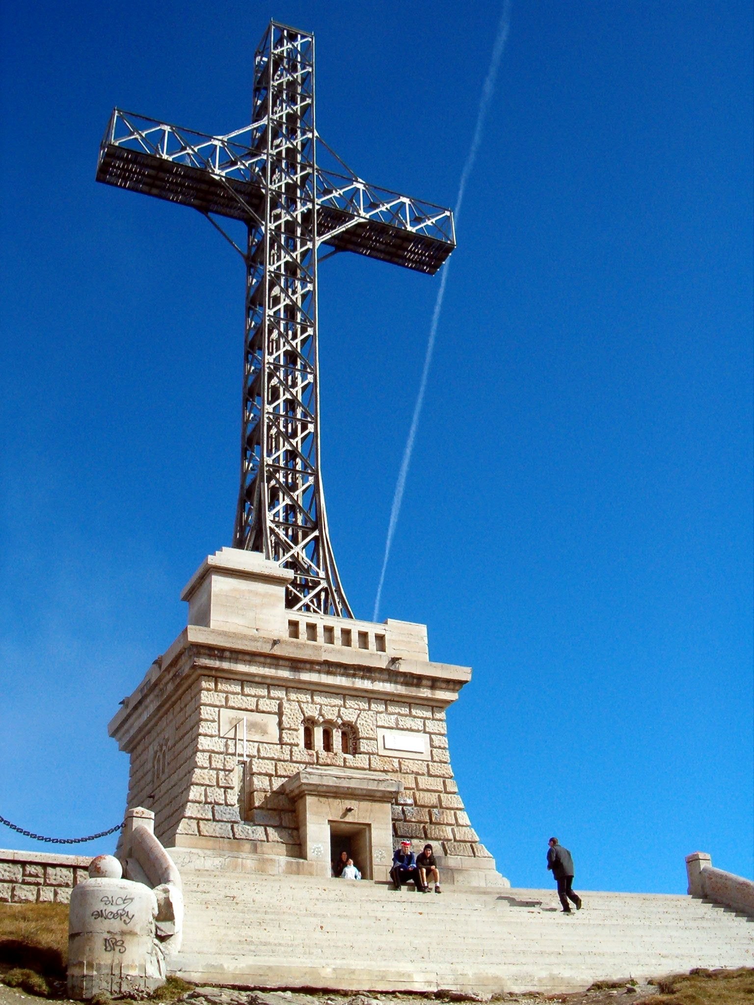
While replaced in most of the European countries after 1945, the forestry railways in Romania survived for a long time: In 1970 the state-run forestry administration still operated more than 3.000 kms of tracks, up to 1986 still new forestry steam locos were built in Romania, and in 1989 still more than 15 forestry railway existed with together approx. 1.000 km of tracks. Some are now being rehabilitated for the purposes of tourism. Mocăniţa is one of the last remaining steam rails still in active use in Europe.


The most well-known mocăniţe:
Vasar Valley, Maramureş - 43 km long, from Vişeu de Sus to Comanu, near the Ukrainian border, though the service may terminate before then at Faina. This trip usually takes between 3 and 4 hours each way. There are two other branches: along the Novat Valley (13 km) and towards Ştevioara (3 km).

Arieş Mountains, Alba County - built in 1912; trains are now operating on Abrud to Câmpeni section of this line, that has 4 stations and 21 stops; it is planned that in the future they will run from Abrud to Turda. When operated as a non-tourist railway the journey time for the 93 kilometres trip from Turda to Abrud took some six and a half hours.


Hârtibaciu Valley, Sibiu County - from Sibiu to Agnita. This line is now designated as a historical monument, so it is saved from being scrapped and the plans to revive it may now go ahead.

Covasna County - from Covasna to Comandău - Regular journeys last occurred here in 1999, but an association was formed in 2002 to save the train and a number of trips have since been made. The inclined plane at Siclău was absolutely unbelievable, operated in the same manner as many funiculars. As soon as it could hear a wagon approaching, the resident horse shunter would appear from its box and with a little bit of persuasion shunt the wagon.


Hunedoara County - from Crişcior to Brad. The line is currently classed as a historical heritage line and used for tourism on holidays.

Mureş County - Târgu-Mureş to Band.

Moldoviţa, Suceava County - built in 1888 the German Louis Ortiep. From the 24 km of the line, there are active 4 km.

Caraş Severin County - Berzasca to Stănic, 32 km.


Photos from here.

Călimani National Park

Călimani Mountains represent the most grandiose volcanic complex of the Romanian Carpathians and the youngest mountains of our country. It cover an area of about 2000 sq. km. laying from north to east on 60 km. It is an immense andhesytic barrier between the two Romanian provinces, Moldavia and Transylvania. Mountains with volcanic origins, Călimani is the biggest crater (without activity) in Europe, measuring about 10 km in diameter. The highest peak is Pietrosul Călimanilor (2103 m), but there are also other formations more than 2000 m height, like Retitis, Călimani Izvor, Călimani Cerbuc.

Photo: Marius Traian Roşca

In 1975, the Biological Research Center in Cluj proposed Călimani Mountains as national park. In 1976, the scientific data for park establishment were gathered in a research work. In 1990, the Ministry for Waters, Forests and Environment declared the park with a surface of 15,300 ha In 2000, the Romanian legislation list the Călimani National Park with a surface of 24,041 ha (actual surface). Since 2003, the park is officially a protected area, category II IUCN, managed for ecosystem protection. The main objectives include preserving wildlife, habitats and landscapes as well as sustainable development of the neighborhood area so that the conservation targets to be achieved; education and research are encouraged, while recreational activities are allowed. Landowners and local communities benefit from their rights in accordance with the conservation management principles. In May 2004, the Călimani National Park Administration was settled as part of the National Authority for Forests Management.

The sulfur quarry in Negoiul Românesc (photo: Alpinet.org)

Călimani National Park shelters a rich variety of wild plants and animals along the rim of the largest volcanic crater in Romania. From the valley floor up the sides of Călimani's crater, a large variety of forest ecosystems thrive: mixed forests of spruce and beech in the Mureş River Valley; spruce forests in the Neagra Valley; mixed forests of spruce and Arolla pine trees in the scientific reservation; and above the tree line, dwarf pine bushes and juniper shrubs. Beyond 1900m are the siliceous alpine grasslands. Călimani National Park plays an important role with respect to the conservation of Romania's wildlife and mountain ecosystems. The beetles identified to date belong to the following 7 families, the Amphibian Class is represented by 8 species, and 5 species of reptiles have been identified. 68 species of birds have been identified through field observation in the north side of the Park. But research on the Calimani Mountains by Milvus Group indicates that there are some 108 species of birds, 21 of which are included in Annex I of the Birds Directive, species requiring the designation of special areas of conservation. Mammals make up a relatively small fauna group in the Park, but are well represented by big carnivores, including brown bear (Ursus arctos L.), wolves (Canis lupus L.) and lynx (Lynx lynx L.); by the weasel family, including otters (Lutra lutra L.), martens (Martes martes L.) and badgers (Meles meles L.); and finally, by the wild cat (Felis silvestris Schrb.).

Saru Dornei (photo: Alpinet.org)

The landscape is also animated by roe deer (Capreolus capreolus L), red deer (Cervus elaphus L) and wild boar (Sus scrofa L), all preferring the abundant fresh grass and remoteness of the Park. We ask that visitors respect the peace and tranquility which makes Calimani such a haven for wildlife. From the rodent family the main source of food for owls and other small predators. The Park is home to fat dormice (Glis glis L.), common dormice (Muscardinus avellanarius L.), wood mice (Apedemus silvaticus) and alpine shrews (Sorex alpinus Schinz). In the Park's forests, two bat species have been observed: the brown long-eared bat (Plecotus auritus L.) and the parti-coloured bat (Vespertilio murinus L.). Both are listed in Annex IV of the Habitats Directive, species requiring strict protection.

The 12 Apostles (photo: Dinu Oprea)

Things to do in Călimani National Park: hiking, mountain biking, equestrian tours, cross country skiing, bird watching, photo hunting, backpacking, paragliding.

Info from the official site of the park.

Prislop Pass

Prislop Pass (Romanian: Pasul Prislop) is a mountain pass in northern Romania, connecting the historical regions of Maramureş and Bukovina over the Rodna Mountains, in the Eastern Carpathians.


The Prislop Pass is situated at an altitude of 1,416 meters, being the highest Romanian pass. It has a length of 50 km and a width ranging from 30-40 km, the north is steep gorge to the south continuing with a gentle slope. The road that crosses the pass (DN18), links Vişeu, Moisei, Borşa (province of Maramureş) with Câmpulung Moldovenesc, Suceava County (province of Moldavia).


In winter the pass is blocked by snow, because of the altitude, but in the summer the tourist has a wonderful view to the Obcinile Bucovinei, to the Rodna Mountains with Pietrosu (2303m) and Ineu (2279m) peaks, and to the springs of Golden Bistriţa. In the second Sunday of August here it takes place the folk festival "Hora de la Prislop" celebrating the descending of the sheep flocks from the mountains.


Photos from Wikipedia.

Bohodei Waterfall

The Bohodei Waterfall (Romanian: Săritoarea Bohodei, En. approx. Bohodei Jump) is the highest waterfall in Apuseni Mountains (Western Carpathians).


The waterfall is located at 15 km from Stâna de Vale Resort; the access is difficult, 8-9 hours with adequate equipment. The water falls from over 80 m on a very inclined slope, a nearly vertical wall. At its base there is a cave-like niche hanged between suspended rocks above the Bohodei Valley.


Photos from here.

Heroes Cross on Caraiman Peak

The Heroes Cross is a monument in the Bucegi Mountains, Southern Carpathians, Prahova County, Romania. It is popularly known as the Cross on Caraiman.


The Heroes Cross is located in the saddle of the Caraiman Mountains, on the slope to the Seacă Valley at an elevation of 2,291 meters; it is unique in Europe, both by the location's altitude and by the monument's size. The cross itself has a height of 28 meters and two arms of 7 meters each. The monument was the tallest structure in the world situated at such an altitude. The width of the vertical pole is 2 metres, the horizontal arms have a length by spindle pole of 7 metres, and a square cross section with sides of 2 metres. The cross is made out of steel profiles and is mounted on a pedestal of concrete clad with stone 7.5 metres high. Inside the pedestal is a room that originally housed the electric generator that powered the 120 light bulbs of 500 W each located on the perimeter of the cross.


The Heroes Cross was built between 1926 and 1928 in the memory of the railway heroes who died on duty in World War I fighting against the armies of the Central Powers. The cross was erected at the initiative of Marie of Edinburgh and King Ferdinand of Romania in order to be seen from a large distance as possible. The overall project was developed by Romanian architects Georges Cristinel and Constantin Procopiu. Queen Marie had closely followed the implementation of her instructions until its completion. Inauguration and blessing of the monument took place on September 14, 1928 on the Holy Cross Day.


The monument was made of metal sleepers joined by riveting in a network pattern. The actual construction was done by the Heroes Cult Society that mobilized a large number of young people. Tools, wood, metal parts, the remaining components and all the necessary materials were transported by train to the Buşteni railway station. From here some metal beams and other building materials were transported by steer and the remaining materials were transported by funicular, owned by the Buşteni Paper Mill. The funicular transported different parts along the Jepilor Valley all the way to Schiel Canton, where they were taken on narrow trails with horses and donkeys to the top of the Caraiman Peak.

Image from Alpinet

In 1939 the Cross was connected to the national energy grid and thus the generator was removed and the new source was the Coştila station complex located at an altitude of 2,487 metres, the link being made through an underground cable. Until the communist regime in 1948, the cross was lit on the night of the Blessed Virgin Mary night (August 15) but also on the Ascension day that coincided to the Heroes Remembrance Day (June 5). The monument is currently administrated by the Buşteni City Council. Nowadays, at night, the Cross on Caraiman is illuminated with 300 light bulbs of 500 W each and can be seen from dozens of miles away, on the Prahova Valley. There is a new project which aims to cover the cross with a fluorescent dye and on top of the cross to be a projected laser spot.

After Wikipedia.

Râmeţ Monastery

Râmeț Monastery is one of the oldest and most renowned worship places in Romania. It is located in Alba County, Transylvania, in Trascău Mountains (Western Carpathians).

Râmeţ Monastery

It seems that the monastery was founded by two monks, father Ghenadie and father Romulus, in 1214. The great scholar Nicolae Iorga showed that the name "Râmeț" is derived from "eremite" (lonely monk). The painting of the old church is a real chronicle of it's history: the first layer is from 1300, and the second layer from 1310. The third layer, on which a text that dates back to 1377 can be deciphered, was laid on the surface of the arch that is situated between the nave and the pronaos; the fourth layer dates from 1450, the fifth layer from 1600, the sixth layer from 1741, and the seventh layer from 1809. The church was painted again by Grigore Popescu between 1987 and 1988.

The old church

Since 1506, the monastery was protected by ruling prince of Wallachia, Radu the Great. During the reign of Michael the Brave, it was restored by princely craftsmen an painters, as Petre the Armenian, Mina and Nicolae from Crete. The holy establishment was abandoned for one hundred years. On 20th August 1762, the monastery was destroyed by cannons on the orders of General Bukow, because it was one of the most celebrated Orthodox places of worship, as well as one of the most powerful centers of Orthodox spirituality in Transylvania. The monastery ran a school which was also devasted in 1762. During the following years, Râmeţ Monastery underwent extensive repairs and restoration works. Nevertheless, it was again destroyed by the Austrian imperial army on December 23, 1785.

The new church

In 1826, the monastery was transformed into a parish church and in 1932 it became a monastery all over again. The newly acquired monastic status was owed to the persevering efforts of a monk, father Evloghie Ota. In 1955, it was transformed into a female monastic community, but in 1960, it was closed down and turned into a touring chalet. In 1982, the monastery received once again official approval from the local state authorities to resume the religious activities that are regularly carried out in a monastic establishment; yet, the outbuildings designed for monastic domestic uses were still occupied by lay lodgers. In order to regain possession of these outbuildings, father confessor Dometie Manolache, Mother Superior Ierusalima Ghibu and the dedicated monastic residents set about constructing a touring chalet outside the monastery grounds. In 1969 the monastery set up a museum to exhibit icons on wood, icons on glass, old books, and an important numismatic collection. The personalities relating to the existence of the museum include: Nicolae Iorga, Vasile Drăguț and Virgil Vătășianu.

Saint Ghelasie

The need of the believers required the building of a new and larger church. The architecture of this church represents a synthesis of the Moldavian and Wallachian architectural styles. Its construction began in 1982 and was finished ten years later, when the church was consecrated on June 29, 1992, and dedicated to the Holy Apostles Peter and Paul. Saint Ghelasie of Râmeţ was father superior of the monastery and the archbishop of Transylvania in the second half of the 14th century, and was canonized the same day. The monastery houses some 95 nuns and sisters who pray and work according to the holy canons of the Orthodox monasteries.

Râmeţ Gorges

The Râmeţ Gorges (Romanian: Cheile Râmeţului) are located in the proximity of Râmeţ commune, Alba County, Transylvania, Romania. Developed at the east of the Trascău Mountains, on the middle flow of the Râmeţ Rivulet, the Râmeţ Gorges are among the most important touristic points from the Apuseni Mountains (Western Carpathians). In its upper part, Râmeţ Rivulet is named by the locals Monastery Valley, and in its lower part, Mogoşului Valley; the rivulet is also named Geoagiului Valley.


At the exit of Trascău Mountains, between Trascău, Urmezu and Vulturilor peaks, it formed a gorges zone of 1 km in length. On the entire length of the gorges, there are traces of an old tunnel-shaped cave. The gradual collapse of the cave ceiling eased the further evolution of the gorges. This can be argued by the fact that the keys have a transverse V-profile, wider at the top. The Râmeţ Gorges are extremely narrow, with steep walls. At the basis of the walls there can be found many caves’ entrances.


Eaves presents a large distribution, both in water and suspended, which reflects the stages of deepening of the river stages in the limestone ridge. The most impressive are found in the area called La Cuptoare, where the gorges are very narrow (3-4 m) and the slopes are eave-shaped. In the central part of the gorges, there is a tunnel with a length of about 15 m and a height of 4-5 m.


After leaving the gorges, 3 km downstream, Râmeţ Rivulet form new gorges, near the Râmeţ Monastery. Though having a length of about 100 m, these gorges are spectacular, having the appearance of a huge gate. Slopes have a V-shaped transverse profile, wide open at the top, presenting numerous towers, poles, and grottoes.


Due to the spectacular landscape and to the special karstic elements that it presents, the Râmeţ Gorges have been declared Geological, Paleontological and Speological Reservation since 1969. The reserve consists of limestone massifs since late Jurassic. In the western part prevails conglomerates, sandstones, marls and marno-calcars, and Cretaceous and Mesozoic basalts in the eastern area.


The vegetation of the area is remarkable, with endemic species as Dianthus spiculifolius, Silene dubia, Aconitum moldavicum, Hepatica transsilvanica, Cardamine glanduligera, Viola jooi, Sorbus dacica, Cephalaria radiata, Campanula rotundifolia ssp. kladniana, Centaurea pinnatifoida, Cirsium furiensis and some rare species as Taxus baccata, Geranium macrorrhizum, Cypripendium calceolus, Aquilegia nigricans ssp. subscaposa, Viola biflora, Daphne cnerorum, Geranium macrorrhizum, Sparganium neglectum, Typha shuttleworthii, Herminium monorchis etc.

Because of the abrupt relief, the gorges can be browsed only along the water during the summer, with a good knowledge of the area and a good training!

Costeşti-Blidaru Fortress

The Dacian fortresses of the Sureanu Mountains (also known as the Orăştie Mountains) are famous in Romania (and an UNESCO World Heritage Site). Here was the capital of the ancient Dacian civilization. Many of the stone structures are still well preserved and open for the public to see. The area is also popular with local hikers as the view from the hill tops is breathtaking. While you are in the area, it's worth visiting some of the other Dacian fortresses. The defensive system of the Dacian fortresses of the Orašţie Mountains was built in the 1st centuries B.C. and A.D. under Dacian rule. These six fortresses (Capâlna, Baniţa, Luncani-Piatra Roşie, Costeşti–Blidaru, Costeşti-Cetăţuie, Sarmizegetusa) show an unusual fusion of military and religious architectural techniques and concepts from the classical world and the late European Iron Age. The six defensive works were conquered by the Romans at the beginning of the 2nd century AD; their extensive and well-preserved remains stand in spectacular natural surroundings and give a dramatic picture of a vigorous and innovative civilization. These Dacian fortresses are outstanding examples of this type of defended site.


The Blidaru Fortress [N 45.667765, E 23.162882] is located at 4 km from Costeşti, uphill the Apa Grădiştei Valley, at an altitude of 705 m - and is considered the most powerful fortress of the Dacian defensive fortification system in Orăştie Mountains. It was conquered by the Romans in 102 AD, later it has been rebuilt by Dacian King Decebal and finally completely destroyed by Roman Emperor Trajan in 106 AD.


On an area of 6000 square meters, can be seen the traces of two twin fortresses, built at different times. The first fortress, which covers the higher plateau of the hill, has the form of a trapezoidal with four outer towers, located in the corners. The entrance was through the first tower. The residence tower, of which the outline is preserved, is placed in such a way so as to prevent enemies from spreading their forces on the inside. The fifth tower, isolated, served as guard tower in front of the entrance (Poiana Perţii tower). West of the first fortress, the second one was built in a pentagon shape, with a single tower, others are common to both fortresses. What draws ones attention here are the war platforms on the northern and southern sides. Here were found also traces of small rooms, used to shelter the defenders of the fortress and warehouses for grain and water, walls constructed of stone and connected with earth, stone, etc. On the lower terraces are four sanctuaries, consisting of alignments of tambours. The two fortresses are remarkable by the originality of the building, strategic position and the technique of building.


Here is also another building, unique in the Dacian world and built, most likely, by a Roman craftsman or under its direction. It's a water tank, building erected outside the fortification on one of the western terraces, below the second fortress, as the water source is at a lower level. It has a height of 4 meters and 6.2 m on 8 m inside, with 2 m thick walls. The walls were covered with an impermeable layer consisting of lime, sand and brick crushing, a typical Roman construction. The mortar does not contain Calcium, still has bactericide properties.

 
General layout:
A. Fortress-1;
B. Fortress-2;
1. Access gate;
2. Observation towers;
3. Residence tower;
4. Water tank.

Systematic archaeological researches started in 1953 after a few random explorations in 1925 on the Muchia Chistoarelor and in 1944 on one of the Făeragului terraces. The upper plateau with the fortification was studied from 1953 until 1959. The 2003 campaign was focused on the research of a tower identified along the road leading from Valea Făeragului towards Luncani, at "La Vămi". The length of the tower is 11.90 m at the exterior and 6.80 m in the interior, the width of the wall is 2.60 m, being built in the technique called "murus dacicus". This tower is one of the many towers placed on the terraces of the Blidaru hill, in the Făeragu-Târşa Luncani area, with a view towards Orăştie and Grădiştea valley. The archaeological material consists of fragmentary gutter and roof tiles.

Ideea and photos from Jurnal Românesc.

The rock figures from Bucegi

Most travelers who come to Bucegi Mountains (120 km North to Bucharest) have heard about the Romanian Sphinx, a strange configuration of rock high on the mountain. Tourists are drawn to its human appearance: proportionate face, distinct lips, cheeks and large eyes beneath a wide forehead. The sight is a thrilling image for the imagination. It is believed the Sphinx, which stands 2,216 meters high, is a representation of the supreme divinity of an ancient people, the Pelasgi, who were a pre-Indo-European tribe who lived near the Aegean Sea, until the Greek tribes' migration up to Eland, Small Asia and Egypt.


"The enormously colossal figure in the Dacian Carpathians transmits a sovereign expression of dignity and an immensity of power that could not possibly represent anyone else but the great, national god of the Pelasgian tribes, whom has been granted all the most imposing heights of the mountains", said historian N. Densuşianu.

Many historians believe the Egyptian Sphinx in Gizeh is a copy of the Sphinx on the Bucegi Plateau because of its resemblance to Zeus. In support of this hypothesis, a resemblance has been acknowledged between the Bucegi Sphinx and a sculpture of Zeus, which was discovered in Italy and now is preserved at the Vatican. This bust presents Zeus's traits in a barbarous, severe figure, characteristic of the Thracians. Also the fact that both sphinxes measure the same height is curious, as is the fact that all Egyptian deities have human bodies and animal heads, except for the Great Egyptian Sphinx, which has a lion's body and a human head.

Near the Romanian Sphinx on the Bucegi Platform, there also stands a group os stones known as Babele (Old Women). The rocks look like giant mushrooms. The three formations are each 3.5 meters high and the diameters of the pedestals vary between 2 and 4 meters. Two of the caps are square, but the top on the third is elliptical. To maintain their connection with the sphinx, they were nicknamed The Cyclopean Altars from the Caraiman, and are devoted to Earth and sky, to sun and moon, and to Mars, the god of war and of agriculture.


Their presence has produced many legends and theories. According to some researchers, the rocks were molded by water and wind and permanently maintained by the process of freezing and thawing. The alternation between grit stone and limestone in the platform also must be taken into account. Yet, researchers cannot deny human involvement in shaping the more or less regular forms; scientific proof cannot thoroughly explain these phenomena. For this reason, the legends continue and the rock formations have been connected with the supernatural.